


Hooker Voting District, Lawrence County, Mississippi
About
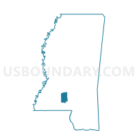
Outline

Summary
| Unique Area Identifier | 605995 |
| Name | Hooker Voting District |
| County | Lawrence County |
| State | Mississippi |
| Area (square miles) | 19.35 |
| Land Area (square miles) | 18.20 |
| Water Area (square miles) | 1.15 |
| % of Land Area | 94.04 |
| % of Water Area | 5.96 |
| Latitude of the Internal Point | 31.61120850 |
| Longtitude of the Internal Point | -90.05690850 |
Maps


Graphs
Select a template below for downloading or customizing gragh for Hooker Voting District, Lawrence County, Mississippi


Neighbors
Neighoring Voting District (by Name) Neighboring Voting District on the Map
- Courthouse Voting District, Lawrence County, MS
- Grange Voting District, Lawrence County, MS
- National Guard Armory Voting District, Lawrence County, MS
- North Silver Creek Voting District, Lawrence County, MS
- South Silver Creek Voting District, Lawrence County, MS
- Stringer Voting District, Lawrence County, MS
- Wanilla Voting District, Lawrence County, MS
- West Monticello Voting District, Lawrence County, MS
Top 10 Neighboring County Subdivision (by Population) Neighboring County Subdivision on the Map
- District 2, Lawrence County, MS (2,645)
- District 1, Lawrence County, MS (2,588)
- District 4, Lawrence County, MS (2,569)
- District 5, Lawrence County, MS (2,282)